
Satellites and a Cool way to use them.
Well this use of satellite technology is anything but cool, in fact it relies on it.
This is the second installment of my bushfire blogs, keep reading to check out the satellite applications in bushfire analysis.
Technology
There has been great developments in the technology used in the fighting of bushfires. NASA has proved to be rather helpful in this respect. They have what’s called Moderate Resolution Imaging Spectroradiometer (MODIS) sensors which are on two of their satellites, the Terra and Aqua (x).
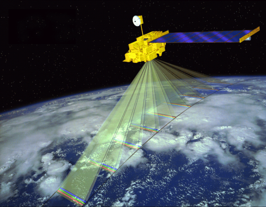
Terra Satellite Source: NASA
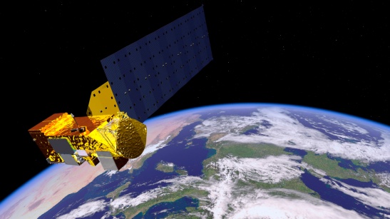
Aqua Satellite Source: NASA
MODIS is based off the theory of infrared wavelengths and thermal imaging.
As short wave incident solar radiation (incoming solar energy) hits the Earth and some of this radiation is absorbed by the Earth some of it is absorbed by the atmosphere.
As we may know this causes warming, however this then means that heat energy is emitted, these waves are longer and are now in the infrared (IR) region, as opposed to the incoming radiation.
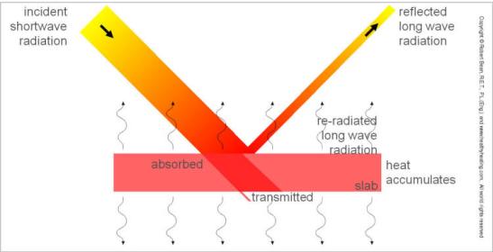
Source: healthyheating.com (x)
As heat is emitted in IR wavelengths, we are able to receive and record this emission at that wavelength. In the same progression, we are able to receive and record the IR waves emitted from any hot body.. just like fire.
So when there is a bushfire MODIS is able to track the movement, growth, and perimeter of the fire. It enables firefighters to make informed decisions about distribution of resources and assign priority order to areas burning or being threatened.
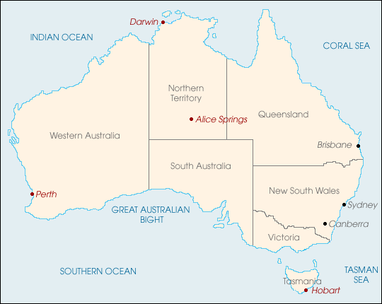
The MODIS sensors send a direct broadcast which can be intercepted with the right radio receiver. After the 2001-02 bushfire season Australia began developing a fire monitoring system using MODIS. Currently there are four receiving stations located around Australia, in Hobart, Perth, Darwin, and Alice Springs, which receive and process the data.
Source: NASA
There is a computer in the Alice Springs receiving station which is dedicated to analysing the data from the infrared and thermal sensors.
From this information the computer identifies ‘hot spots’ which are areas that show unexpectedly high levels of heat, which naturally can indicate the presence of fire. There are other things that will emit, such as roads that have absorbed the suns heat all day, however the computer can tell which spots are being caused by a bushfire. The temperature and pattern will be quite different to that of a road.
These ‘hot spots’ are then packaged up into a data file and sent around the nation to the concerned parties.
The other immeasurably important analysis that has come from MODIS, is that it has the ability to distinguish between active flaming fires and smouldering burn scars. [you can find more information about this here]
This has developed into the Sentinel project, which has bought this information into the digital age. Sentinel is available from any webpage, which can provide information in near real time. Have a look here. As you can see it shows where fires have been and have the estimated time that they occurred.
This has had life changing impacts during bushfire seasons, my favourite however is the use if IR and thermal imaging to locate smouldering trees and neutralise them. When a bushfire runs through the bush/forest much of the lighter vegetation burns up and fuels the fire’s progress.
However as the front of the fire moves on the larger vegetation; trees, don’t immediately extinguish they continue to burn. Smouldering trees and debris, are one of the major dangers of bushfires.
‘After the fire front has passed’ is a critical stage of a bushfire, because even days after the fire smouldering fuel can reignite. Trees or their stumps can smoulder for weeks after a fire. The thermal and IR imaging can be used to locate these smouldering stumps and trees, this is particularly useful in areas that provide no access for crews in which fires are mostly fought from the air .
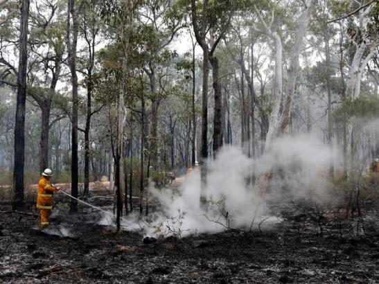
Fire fighter Phil Wilson douses some smouldering tree trunks in the fire area near Wilton. Source: The Daily Telegraph (x)
Firies then are able extinguish the long/stump/tree if conditions could mean threat of re-ignition or are able to monitor it whilst it smoulders and eventually burns out.
These technologies and their applications are really important for the ground work that goes on during a bushfire.
Environmental
Just before I finish up this blog I want to run you through some of the environmental facets that are up on offer when bushfires are involved.
[Original prezi here]
That’s all for this week, the final blog will be up next week see you then 🙂
To be continued…
References
[1] Densmore, V. S., et al. (2013). Wattle-It-Be? Key factors influencing regeneration of Acicia after bushfire. B. CRC and T. U. o. Sydney.
[2] Burrows, R. b. N. (2016). “Firestick Ecology: Fairdinkum Science in Plain English.” International Journal of Wildland Fire: -.
From the prezi, Environmental
Robinson-Koss, M. (2012). “Australian Forests and Fire Regeneration: Fire adaptability in Forest Species.” Retrieved 29 April 2016.
Mathiesen, K. (2016). World herritage forests burn as global tragedy unfolds in Tasmania. The Guardian.
One comment on “Satellites and a Cool way to use them.”
Leave a comment
Deakin Authors
-
acoffey2409
Adam
-
adecorra
-
aengledo
-
ainaajmal
-
alknorris
ameliafrawley
-
anberzara
-
andreagioulek
-
Andrew Mahony
-
andyfung141
-
anhdang16
-
anitapsara
-
apmcdona
-
aserwin1501
-
Optimmis.prime.blog
avzta
-
ayalidi
-
bakercrystal92
-
BTJohnson
-
benclarke1
-
benlivingstone7
-
bimalig
-
binlublogassignment
-
bluebandedbee
-
bnewma
-
brantpetersen
-
bryce1234567
-
brycecorban
-
callummeldrum
-
captainrory
-
carliwindridge
-
catfraser29
-
cherylkwong
-
chrisjhicks
-
chrisjwalker
-
cjhadley
-
cjsharp2014
-
claudiablain
claudzz7
-
clschult
-
cmarino32
-
cohencraven
-
cworrell
-
Connor
-
danameieruni
-
danieltabone
-
dariannyholt
-
davisjonathan
-
dyl
-
smpearso
-
demagi
-
djchivers
-
djpye
-
dlcd31
-
EmCarter
-
earkal
-
rosemarieraftellis
-
eleisadrose
-
elenagazis
-
ellakim1993
-
ellieheald
-
elobitana
-
emilyobeirne013
-
emineailmovska
-
ewvs
-
ffongg
-
flick102
-
flickgordon
gamesofdiscovery
-
George Aranda
-
ginachin93
-
gmleszczynski
-
Georgia Woodhead
-
gtsuchid
-
hanhhe
-
hanihersi
-
harrisonhooper
harthur2015
-
ihavead0g
-
indtoaus0910
-
isabelle.johnson
-
isabelleplusscience
-
j4ck3l
-
jackson3732
-
jamesmcginley15
-
Jane
-
jasmanpotra
-
jcollinsweb
jcrippsclark
-
jdarbs0205
-
jenniferjt1105
-
jessthepharmacygirl
-
Jessica Liew
-
jesspeartree
-
jkanjodeakin
-
joannaesc
-
jordancambie
-
josephkolotelo
-
joshykloog
-
jteee1
-
juliarachelsholo
-
jwello
-
karlwilkins
-
katelynmcc
-
kayleighsingh
-
kblade96
-
kedaviblog
-
kirstyleemcnamara
-
kanan
-
kruuska
-
ksmyt
-
laurabdeakin
-
lcarlisl
leissa
-
Jklyon
-
lestercorncrake
lhobbs2015
-
Lisa
-
lizkawka
-
ljborley
-
lkostov
lockehood
-
louisvescio
lvescioblog
-
mabubaka
-
maddimace
-
Mark H
-
matb1
-
meganrw7
-
mgeorgat
-
miggyn
-
mmillard96
-
monamola
-
moyakviz
-
mpepper44
-
mthiik
-
mtsipnis
-
naimahassen
-
natashagigliotti
naveenimran
-
Nez
nghibnguyen
-
nobodyknowzyet
-
nquilty
-
paigerigby
-
pamudi
-
pasindi
-
pmwatts95
-
ptmitche
-
rachelmcnamarablog
-
rammerjammerok
-
rbburgess
-
rebeccagreenm
-
rebeccapinder
-
reneebisscheroux
-
rgdicg
-
rmello1
-
roksaa
-
rrupra
-
samnang2016
-
sandaliii
-
sarahjanejomantas
-
scientificblogsite
-
scithunk
-
sebastiandayhenri
-
sebrawson
-
sesparon
-
Sarah Smith
-
shan1126
-
shenaeryan
-
sineadmcgarrigle
-
skyvalley9
sophia701
-
sophiiee10
-
sporrett
-
squeakscruffy
-
SamJ
-
ssq1996
syrenol
-
tanvi05
-
taratylinski
-
Tegan
-
timothyjanes
-
tjdunkle
tjslim
tjwrig
-
tristanfernandez
-
tsaganasnick
-
tylerjwebb
-
wassssana
-
wdrogemu
williamalbrecht
-
wjhar
-
wkerrydeakineduau
-
wx85zs
-
zakkihusaini
-
ZoeJNicholson
-
zoeb156

Pingback: And All I Saw Was Screaming Colour | Deakin Communicating Science 2016